


"A holiday on the Isle of Mull is perfect for exploring the spectacular wildlife Scotland has to offer"
Craignure to Bunessan by car – the pictorial version

The Isle of Mull ferry at Craignure Pier
0 miles

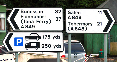
As you drive off the ferry, you will see this road sign straight in front of
you. Turn left onto the A849 towards Bunessan, keeping the sea on your left
and the Tourist Information Office on your right.
0.4 miles

Follow the road as it curves to the right away from the sea and up the hill,
passing the turn to the camping site on your left and the
Craignure Inn on your right.
0.7 miles - The dual track road changes to single track road. Always keep to the left at passing places (which are marked by black and white poles), even if the passing place is on the right hand side of the road, and be considerate to other road users by using the passing places to allow faster moving traffic to overtake you. There is a good guide to correct single track road “etiquette” here: http://www.holidaymull.co.uk/mull/roads
1.5 miles

The entrance to Torosay Castle
and Gardens is on the left here.
1.8 miles

Continue on past the turn off to Duart Castle, signposted “Kirkpatrick". This is where “Entrapment” was filmed. During the summer there are many events held here including re-enactments and treasure hunts.
2.6 miles

You will pass through the village of Lochdon, at the head of Loch Don, with
part-time 20 MPH speed restriction for the primary school.
3.2 miles

Pass the turn off to Grasspoint at the mouth of Loch Don on your left. Sea
eagles may be seen at Grasspoint fairly regularly.
5.7 miles


You pass the mussel farm at the head of Loch Spelve. Mussels can be purchased
from the farm in 2Kg or 5Kg bags; they are delicious steamed in a little
white wine, shallots and cream...
6.4 miles

Pass the turn off to Lochbuie and Croggan on your left.
6.6-10.7 miles

Go over 4 cattle grids as you pass through forested areas. As you emerge from
the forest over the second cattle grid, the first of a series of mountains
comes into view. This is Beinn Talaidh, 763 metres high.
11.6 miles

Away to your left are Loch Airdeglais, Loch an Ellen and Loch Sguabain. After
this point, you start to descend through Glen More and golden eagles can
often be seen soaring here. The old road can be seen winding through the
glen with many of the old bridges still standing.
17.4 miles


Carry on along the A849 towards Fionnphort, passing the turn off for the scenic
road to Salen on your right. As you cross the Coladoir River, the old stone
road bridge can be seen on your right, beyond which are the Kinloch Hotel
and the head of Loch Scridain.
17.9 miles - Entrance to Pennyghael village. This is a sparsely
populated village which is spread out over several miles.
18.3 miles

Look out on your right for the only pink milepost on Mull, with views of Ben
More across the loch in the distance. At 966 metres in height this is one
of the few island Munros (the only other Scottish island that can boast any
Munros is Skye).
18.6 miles - You pass the Kinloch Hotel on your left; this
is the end point of the Kinloch Ford walk across the mouth of the Coladoir
River, which should only be attempted at low tide.
20.2 miles

There is a rather narrow bridge over the mouth of the Leidle River at the heart
of Pennyghael.
20.4 miles

Carry on past the road to Carsaig which goes off to the left soon after the
village centre. It is possible to walk east along the south coast from Carsaig
to Lochbuie, and walking west from Carsaig will take you to the Nun’s cave
(where a group of nuns lived when they were ousted from Iona and their wall
carving can still be seen) and to Carsaig Arches.
21.3 miles - The end of Pennyghael village
22.5 miles - Be aware that there is another narrow angled
bridge here and large vehicles may need to take a wide sweep to avoid the walls.
Away in the distance across Loch Scridain can be seen the islands of Staffa,
Coll and Tiree and the Treshnish Isles. Just across the loch is the starkly
beautiful shape of the looming escarpment by Burg; a 55 million years old fossil tree can
be found on the shore nearby. Watch out for otters in the sea margins
along this stretch of road.
28.3 miles

Carry straight on at the crossroads to Lee, Knockan and Ardtun, with Bunessan
Primary school just visible over the next rise.
29.3 miles

Bunessan Primary School (to the right) is the site where the Bunessan Show
is held, usually on the first Friday in August.
29.6 mile

Carry on past the turn off to Scoor on your left. This track takes you to a
car park from where a path goes down to the ruined 13th century Kilvickeon
Chapel and burial ground and beyond to the spectacular Kilvickeon beach.
You can also walk to the deserted township of Shiaba over the cliff top.
29.8 miles

As you enter Bunessan, the road becomes dual track for a short distance.
The Ross of Mull Historical Centre can be seen to your right. Here you can
explore the history of the Ross and discover the many signed walks that
can be undertaken in the area. The river is the site of the annual Easter
Duck Race.
29.9 miles

Carry on past the turn off to the right, which takes you round the Ardtun peninsula.
The fossil leaf beds can be accessed from this road.
30.0 miles

Drive through Bunessan village where you can find a Spar shop, the Argyll Arms
Hotel, the Blackbird Bistro, and the fire station. Carry on past the turn off to your left in the
middle of the village, which goes to Uisken beach where there are lovely
views across to Colonsay, Islay and Jura. This is the site of the Uisken Games in the summer.
The huge Ardalanish beach is also this way - you will find The Isle of Mull
Weavers and their organic farm down this road and the beach is where the
annual shinty match is battled out on New Years Day.
30.7 miles

Bunessan Pier is to your right as the road starts to curve to the left up the
hill. The ruined township of Suidhe can be seen on the skyline.
30.8 miles

Carry on past the road to Bunessan cemetery on your right. You can now see the cottages appearing at the top of the hill, to the right of the road.
30.9 miles

As you come up the hill, you will see this sign on the wall of the
courtyard, just as you pass the cottage nearest the road (Ros-Mairi).
31.0 miles

The entrance to Suidhe Farm Cottages is on your right at the top of the hill. There is ample parking space for two cars next to each cottage.
© SUIDHE FARM COTTAGES 2017 | Site Map |
- A perfect holiday on the Isle of Mull -